In the past year I started using public transportation ALOT. I didn't before because, while I can read some characters, I can't read nearly well enough to read those bus maps fast enough to determine where I want to go and how. BUT that all changed the day I discovered that Google Maps will give you public transit directions. (I know this works in Taipei, Hong Kong, Beijing, Shanghai, Chengdu, Wuhan, Philadelphia, New York, Washington DC, Tokyo, Osaka, and Fukuoka ) Now, I'm not an expert, but I can at least get you started. I did this tutorial using my google maps phone app (it's the same for both android and apple) but you can do the same thing with
Google Maps on the computer using the mouse instead of touching the screen.
First, you will want to open your google maps app (this is different from the preloaded maps app on an apple device, DON'T USE THAT, it's not good). You'll see a lot of Chinese on the maps, but there's also Pinyin, so you don't have to be able to read Chinese to use this (and if you're not in China there won't be any Chinese at all!)
When you do you'll get a basic map screen, that will show you your current location. Decide where you want to go, and then you can either drag the map there with your finger, or search for it using the search bar at the top of the screen. I recently went from the
Flower and Bird Market, to Beihu lake so we'll use that as the example. This screen is roughly where the flower and bird market is.
Touch the map on the screen at approximately where you want to go (or type in an address, or location, in the search bar at the top). It will give you an approximate address at the bottom of the screen.
touch the address at the bottom of the screen and you will see a page like this:
At the very top of the screen there is a car, a bus, and a person walking. If you want public transportation, touch the car. The pink arrow shows your beginning and ending points (the default is from your current location, but I just added Beihu lake as the endpoint instead). The purple arrow shows the one of the route options you have. I usually get 3 or 4 different route options, but this one only has two. Each option tells you approximately how long it will take and the bus/train number you will need to take. In order to get directions, you need to select one of the routes.
The purple arrow at the top shows your starting and ending point and what method of transportation you are using. The green arrow is showing you the route you selected, which will usually be highlighted in blue. The pink arrow at the bottom shows which transportation option you are using (if you swipe here you will see the other route options if you decide you want to switch).

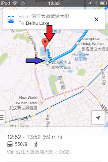
And here is your end point, usually highlighted with a red flag (drop pin, marker, what is that?). When you see a bunch of blue dots (at the blue arrow) that means you are walking. One of the cool things about using the mobile app, is that you can follow your progress in the map by watching the flashing blue dot as it moves along your route. This is a helpful feature because I sometimes will get on a bus going the wrong way. But it is also good because often the name of the stop is not immediately obvious and the blue dot will tell you when you are getting close to the point where you need to get off the bus/train.
So there you have it! Getting around has never been easier right?
PS, if you live and china and want to buy a bus card (or if you have one and you want to refill it) go to the Hongbai grocery stores, there's a counter, usually near the doors that will chongzhi (充值) (refill your card). In Taiwan, you can do this at the ever helpful 7-11!


